Well! We're already in August, and the summer is starting to slip by... And what a nice summer it's been. Plenty of beautiful weather, including the day with the highest recorded temperature ever in Reyjavík (26.2 degrees Celsius / 79 degrees Fahrenheit!). It's almost too good, for this place.
Don't be fooled by the lull in posting, we've been doing plenty of stuff this summer :). And there will be other posts after this one detailing our activities.
But this post is about hiking the Laugavegurinn trail. In mid-July, we decided, along with 4 friends of ours, to do this hike. It's a 3 day hike, 55 kms (34 miles) long , which takes you from the rhyolite mountains of Landmannalagar, through geothermal areas, to fields of obsidian rock, to a black sand wasteland, and finally through a real Icelandic forest (birch trees) with a great view of several glaciers. Oh and along the way, there are several unbridged glacial rivers, which we had to cross by foot. It was a seriously intense experience for me... As I'm sure Jó could tell you.
We camped for two nights, and carried all our stuff in our backpacks (which weighed close to 14 kilos / 30 pounds). The last day was particularly intense as we had to catch a bus by 3.30, and Jó had to soldier on through her 7-8 blisters to get there... But we made it! And as soon as we did, it started raining, after 3 days of great weather. That's luck.
Oh, the cabin at the end of the trail sells hot dogs. After three days of freeze-dried food and whatnot, those were the best hot dogs I've ever had.
And, now, the pictures. Many thanks to Jó for taking most of them! We had to do with the small camera, as the nicer one would have been to heavy to carry on the trip.


 Rugged
 The view of the first campsite, surrounded by shiny obsidian rocks
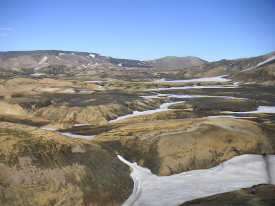
 The snow looks like rivers between the mountains
 A geothermal stream. Some spots even had boiling water!
 The best view of the trip... Álftavatn lake viewed from a mountain 500 meters above it.
 A mountain in the sunset, around 11pm.
 Crossing the long black wasteland. People call it a desert though it's technically too wet to be a one, but it has almost no vegetation.
 The glacier, always showing us the way
 A (luckily) bridged river crossing
 We had to go up and down so many mountains...
 A very red field
 The birch forests of Þórsmörk
 On the way back, the bus had to cross some rivers too...
3 comments:
Gorgeous photos! I had no idea you could see Álftavatn from there ... we spent two days hiking around it a couple of years ago, VERY beautiful!
Thanks Alda! Yup, it's a beautiful area...
Amazing pictures. Some of them look like they were taken on another planet, or at least an ancient version of this one...
Post a Comment